The Travelling Bag series was originally curated to connect our global community, by passing a bag and a single journal traveller to traveller, adventure to adventure. It has since become a collection of mindful travel guides, encouraging each owner of The Travelling Bag to delve deeper into the place they're exploring, focusing on travelling against the norm and finding meaningful connections with the places they visit.
Our first journey of 2019 begins close to home - the Borrowdale Valley, in the Lake District. Emily and Felicity from This Way, are modern cartographers who spent a long weekend up North, wandering some of our favourite paths (included taking some time to visit Millican Dalton's cave). You can experience their trip by buying one of their Borrowdale Valley maps, which illustrates their Lakeland adventure with the Travelling Bag.
Words by This Way | @follow_this_way_maps
Photography by Curtis James | @oswald808

This trip had been in our calendars for over a month, and we knew we were stretching the end of summer as far as we could push it. Text messages flew between us considering the possibility that the weather would be too unkind to pitch our tents for the weekend. Storm Bronagh hit the UK the weekend before, the temperatures suddenly plummeted, and sunset crept nearer each day. Just before we were due to set off we did a final weather check, and blue skies were all we could see, so we packed our bags with far too much stuff and headed north.
The journey to the Lakes always starts the same, waking up before the sun has risen, packing the car while trying not to wake the neighbours and following the same boring motorways, creeping slower than we’d like towards the mountains.
"There’s always anticipation heading north, waiting for the unchanging views of the motorway to reveal the first glimpses of mountains and moorland as the road cuts through the Far Eastern Fells and the Yorkshire Dales."
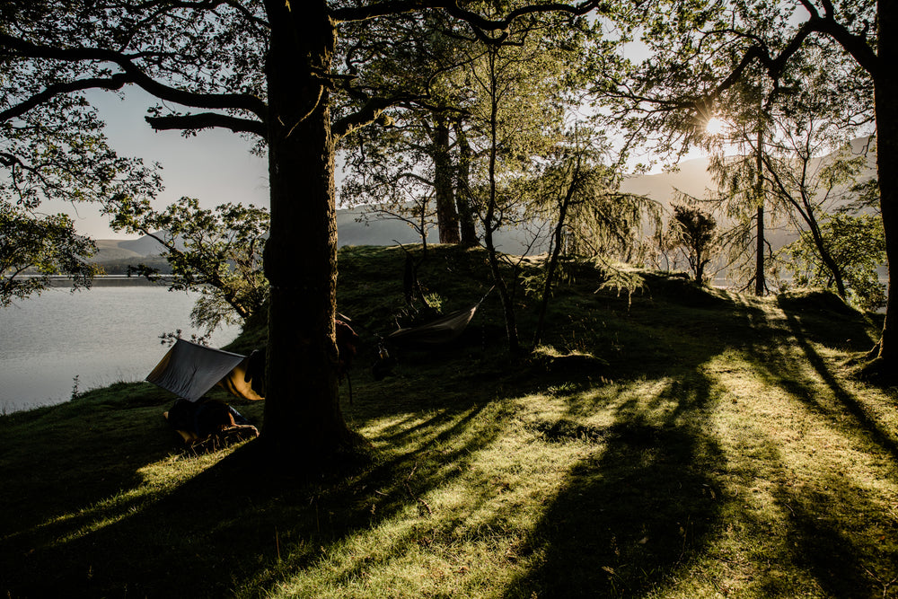
We pitched up our tent in a small and empty, out-of-season campsite, perfectly positioned alongside the footpath we planned to hike and map. Even though we work closely together to document our favourite hikes across the UK, it is a rarity that we find ourselves camping together, and it was the first time the two of us had visited the Lakes for a This Way project. Our camp grew around a small fire that promised a little light and warmth, something we’d need once the sun went down.


Wanting to make the most of the late afternoon light we decide to pay a visit to the smallest of the Wainwright peaks. Measuring only 290 meters, Castle Crag is a perfect miniature mountain. The path starts in a wooded valley before entering a small mountain pass, after climbing steeply we met a section of trail disguised as a pile of slate and scree. The views from the top are far better than it’s size suggests. On this clear evening, we could see the first moments of the dying sun sink below the horizon, leaving the sky awash with beautiful pastel tones over Derwent Water and Keswick. We made our way down and through the woods in the dark, back to our camp and the welcome luxury of sausages, smash, beans and a cold bottle of red wine.
Drifting off in our tents, wrapped up to guard against the cold, our dreams became influenced by the sounds encircling our camp. Imaginary deer crept around our tents and not so imaginary owls hooted in the branches above. In the early hours of the morning a plane rumbled down the valley practising its low-level flying by the light of the full moon, and for a while we could not distinguish whether this sound had been real or part of a dream.
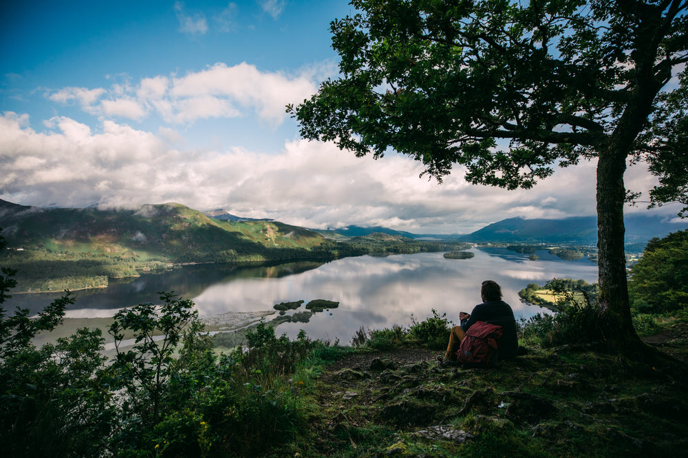
We unzipped our tents in the morning and perfect blue skies greeted us, the sun was gradually creeping down the ridge that was to be today's route. The cold September morning quickly burnt off and by the time we hit the foot of Cat Bells the air was warm. The route up this fell follows one popular path, busy with people making the most of the unusual late September weather. The path did not disappoint, the very well defined trail soon presented small sections of rocky outcrops to scramble up, each person picking their preferred route. As the height grew so did the views, firstly of the ripples left behind by boats on Derwent Water, then onwards to the Northern Fells. To the West, the mountain dropped steeply into the valley, reminding us of the ridge we were perched on. We reached the peak of Cat Bells at lunchtime and along with many others, decided that this was by far the best place to rest and unpack a sandwich.


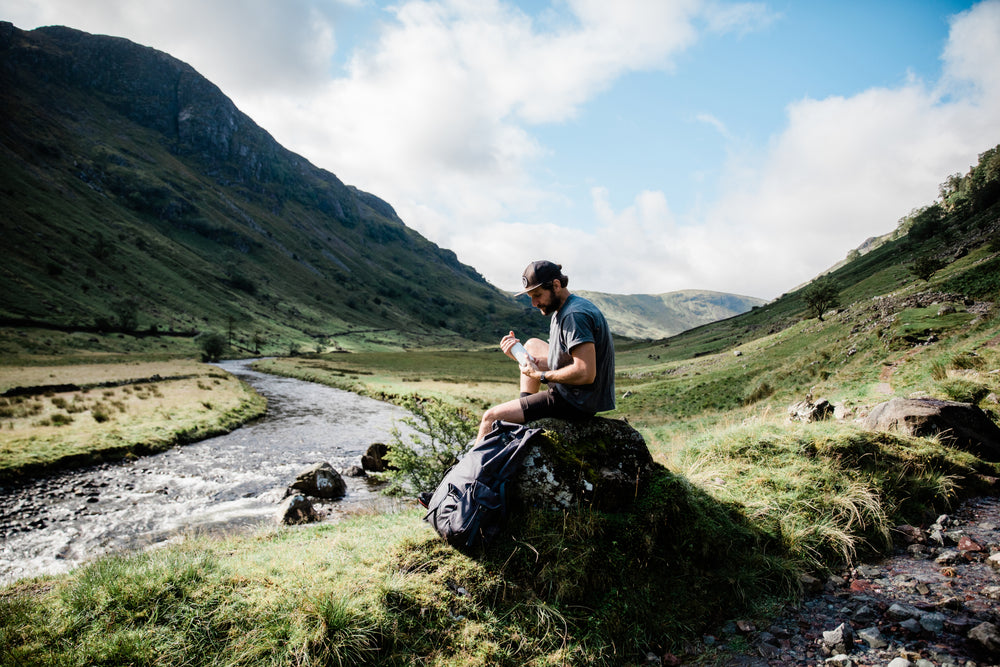
As we headed South, past the summit, the crowds dispersed retracing their steps back down to the Lake. Our path, which was suddenly quiet, led onwards towards two further peaks, and we began this stretch of the journey alone. The initial steep slopes of Cat Bells were replaced with a gradual incline upwards as we traced this string of mountains. Deep in conversation and not noticing our tiring legs we reached Maiden Moor without realising we had done so and then found ourselves at the large cairn of High Spy, which marked the start of our descent. Suddenly, the lesser popularity of this peak became apparent as the path we had been faithfully following vanished from view. We headed across a bog for a distant style, trusting that this was the start of an old mine track that would lead us back down into the valley. Thankfully our instincts were right, and after a quick rest for some crumbling Kendal Mint Cake we started our descent.
"The landscape once again changed, and the desolation surrounding the remnants of old industry was all around us. Full of intrigue, we peered into the eerie endless darkness of open mine shafts that lined the sides of the steep path. Back down in the valley, our pace slowed, and the kind of weariness that only comes near the end of a hike crept in. The promise of a warm shower and pub dinner kept us plodding on."
When we finally returned to our solitary camp spot we found a man standing in the middle of the clearing looking intently up at the cliff that faced us. Thinking he was a wildlife spotter of some variety, we joined him to see what he was tracking up on the vertical rocks. To our amazement, he was a surprisingly calm father, positioned to film his son undertake his third base jump of the day. We nervously joined him with our binoculars. After around 30 minutes, taking care to make sure his position and the conditions were just right, and gambling with the dying light, the base jumper leapt off the side of the mountain. With what felt like too few seconds to control his decent he expertly swooped into camp and landed meters away from us. With a flurry of questions and a quick view of his head-cam footage, he packed up the lifesaving contents of his rucksack and they were gone.
We didn’t have a big walk planned for our final day but we did have a few things to tick off our list. We knew we’d passed the area where Millican Dalton’s Lakeland dwelling was hidden but had run out of light before finding the exact cave he called home. So we retraced our steps, joined a clear path leading up into a disused quarry and quickly found a cave, not the right cave but one that suggested we were looking in the right place. Further up the slope where the path ended were the two interconnected caves, both full of small clues that this was a regular pilgrimage for other adventurers, many spending a night protected from the elements under the overhanging rock above. We spent a while exploring the caves, imagining it was a home and wondering how Millican Dalton might have inhabited the space.


Our final stop visited one of the Lake Districts more unusual attractions. As we pulled up into the car park we were greeted by an older couple, at first noticing the woman with her brilliant tangerine hair and then her husband with a grubby handful of mushrooms. They pointed out the various types of fungi, describing which ones were edible and which ones should be avoided. The man generously held out a mouthful for us to try which was greeted by two fearful faces, neither of us wanting to risk a bite of something potentially poisonous. Our path led on to the Bowder Stone, an old Victorian attraction which led paying visitors up a wooden staircase to the top of what was once described as ‘probably’ the biggest stone in the world. After climbing the large boulder, our bellies started to grumble, so we decide to drive back to camp via Keswick and the fish and chip shop. The route back took in two mountain passes and turned what should have been a 5-minute drive into a breathtaking 45-minute adventure. With stocks replenished we had one final night around the campfire. We shared stories of past adventures and dreamt of future ones knowing that the morning was the start of our long drive home on those never-ending motorways.